


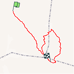
SityTrail - J6 - Rif Brentei -- Rif Pedrotti-F

GAPIAN43
User

Length
7.5 km

Max alt
2858 m

Uphill gradient
966 m
Km-Effort
19.4 km

Min alt
2170 m

Downhill gradient
665 m
Boucle
No
Creation date :
2019-07-27 08:36:40.957
Updated on :
2019-08-05 07:15:35.825
--
Difficulty : Difficult

FREE GPS app for hiking
 SityTrail
IGN / Geographical institutes
SityTrail Plus
The world is yours!
About
Trail Via ferrata of 7.5 km to be discovered at Trentino-Alto Adige/Südtirol, Provincia di Trento, Tre Ville. This trail is proposed by GAPIAN43.
Positioning
Country:
Italy
Region :
Trentino-Alto Adige/Südtirol
Department/Province :
Provincia di Trento
Municipality :
Tre Ville
Location:
Unknown
Start:(Dec)
Start:(UTM)
644819 ; 5115232 (32T) N.
Comments